About Andrew Cusack
 Writer, web designer, etc.; born in New York; educated in Argentina, Scotland, and South Africa; now based in London.
 read more
News
Blogs
Reviews & Periodicals
Arts & Design
World
France
Mitteleuropa
Knickerbockers
Argentina
The Levant
Africa
Cape of Good Hope
Netherlands
Scandinavia
Québec
India
Muscovy
Germany
Academica
Paris Arts & American Arms
Maj. T. L. Johnson’s Cartographic Mural on Governors Island
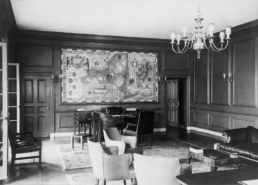
One of the best aspects of the inter-war construction of Governors Island is that the refinement of McKim Mead & White’s architecture is matched inside by a series of interior murals painted under the auspices of the WPA. These murals often veered towards the refreshingly jocular, as can be seen in the War of 1812 mural in Pershing Hall (a corner of which is captured here by photographer Andrew Moore). The mural by Major Tom Loftin Johnson (educated at the Ecole des Beaux-Arts in Paris) depicted here, however, is a map of the area under the purview of the Second Corps, U.S. Army headquartered at Governors Island; namely the states of New York, New Jersey, and Delaware, and the then-territory of Puerto Rico.
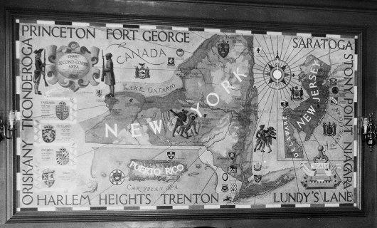
The map includes a great deal of heraldry. The arms of New York, New Jersey, and Delaware are depicted next to their respective places, as are those of Puerto Rico (one of the most Catholic coat of arms in the United States). The arms (or, in military parlance, Distinctive Unit Insignia) of various army units within these lands are shown, including an incorrect rendering of the arms of West Point, the United States Military Academy, near its location along the Hudson (odd, considering Maj. Johnson was an art instructor at the academy). Delving further into this heraldic miscellany, the artist has depicted the arms of the European houses that colonized the Second Corps region: the arms of France uppermost in northern New York, with the arms of Great Britain, Holland, Sweden, and Spain off to the left. The names of ten battles from the Revolution circle the entire composition.
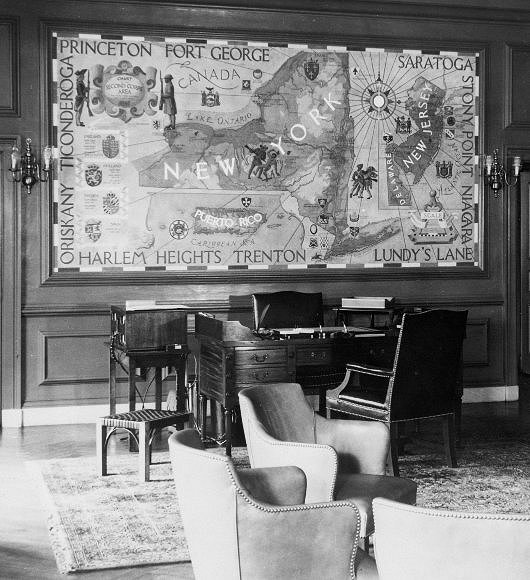
On the whole, a charming combination of cartography, heraldry, history, and design that lends a particular appropriateness to the term “military arts”.
Category: Governors Island
Search
Instagram: @andcusack
Click here for my Instagram photos.Most Recent Posts
- Waarburg October 2, 2024
- A Prize for the General September 23, 2024
- Articles of Note: 17 September 2024 September 17, 2024
- Equality September 16, 2024
- Rough Notes of Kinderhook September 13, 2024
Most Recent Comments
Book Wishlist
Monthly Archives
Categories

