London, GB | Formerly of New York, Buenos Aires, Fife, and the Western Cape. | Saoránach d’Éirinn.

About Andrew Cusack
 Writer, web designer, etc.; born in New York; educated in Argentina, Scotland, and South Africa; now based in London.
 read more
News
Blogs
Reviews & Periodicals
Arts & Design
World
France
Mitteleuropa
Knickerbockers
Argentina
The Levant
Africa
Cape of Good Hope
Netherlands
Scandinavia
Québec
India
Muscovy
Germany
Academica
Cape to Cairo
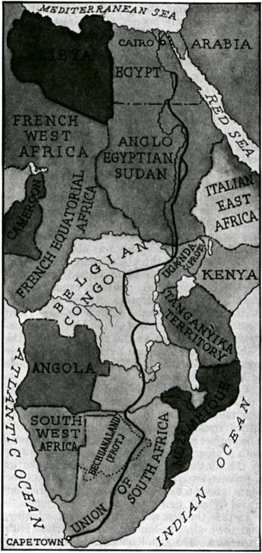
The Cape-to-Cairo railway — the famous dream of Cecil Rhodes — of course never actually came to fruition, though after the Second World War the British Imperial pink on maps did stretch the desired length of Africa. This map is a bit curious for showing Northern and Southern Rhodesia as having joined the Union of South Africa, which they opted against. It also seems strange that, given that the whole idea of the Cape-to-Cairo was that it be a railway on British territory, this map shows it instead weaving a circuitous route through the Belgian Congo.
Published at 12:39 pm on Tuesday 24 March 2009. Categories: Cape Town History South Africa Tags: Africa, Great Britain, History, Maps.
Search
Instagram: @andcusack
Click here for my Instagram photos.Most Recent Posts
- West Point July 30, 2026
- Brunel’s Unbuilt Capitol February 3, 2026
- Cricket at Fordham January 27, 2026
- Palacio Barolo Revisted January 14, 2026
- Learning to Love Liguria January 14, 2026
Most Recent Comments
Book Wishlist
Monthly Archives
Categories

Home | About | Contact | Paginated Index | Twitter | Facebook | RSS/Atom Feed
andrewcusack.com | © Andrew Cusack 2004-present (Unless otherwise stated)

Tanganyike at the time was a German colony. Perhaps the British preferred that their railroad traverse Belgian rather than German territory??
This map is from the interwar period. Tanganyika was a British territory by then.
Are you planning a treck North Mr Cusack?
That would explain it.
The League of Nations entrusted Taganyika to the British as a mandate, in which they were forbidden to construct military or naval bases.
http://en.wikipedia.org/wiki/League_of_Nations_Mandate
The British would not have been allowed to construct facilities to assist the transport of military materiel through the territory, and quite likely wouldn’t even have been able to move soldiers and possibly even weapons on a Trans-Taganyikan railroad.
Bear in mind that Paul von Lettow-Vorbeck’s audacious and spectacular guerilla campaign during the war, which had included the destruction of railroads, had left a deep impression and engendered many warm feelings among the tribes of Tanganyika.
A family member there in the 60s remembers how the old men would proudly show her the goose-stepping they had learned as German askaris.
The British may have felt that the tribes of the Belgian colony were much less likely to be a problem in the event of another clash with Germany, and wanted to align Belgian and British interests.
It is probably just an idea of the person who drew the map rather than based on any serious plan. I had a school friend whose father drove his family the length of Africa from Pretoria to Beirut in the early 1950’s, and from the time they left South Africa (then a dominion like Canada)until they crossed the Sudanese – Egyptian frontier, travelled exclusively across British colonial territory. Apart from wear and tear on the vehicles they encountered no really bad roads, though they were mostly dirt, no malaria (largely eradicated), no crime, friendly people, and had a journey of their lives. I doubt whether you could drive around a street in Pretoria today without your car falling into a pothole or without being mugged, let alone cross Africa without serious incident.
It’s very intresting to see that Rhodesia is shown as is part of South Africa, and Bechuanaland is a seperated by dotted lines. The map clearly dates from 1936-1939, as Ethiopia is shown as part of Italian East Africa, during the Italian occupation(emphasis on occupation). During this time Britain recognized the colony, had it been published after the outbreak of the Second World War, Ethiopia as a nation “in the same basket” as the Allies would’ve been indicated occupied.